
Fil:KureAtoll.jpg

Størrelse på denne forhåndsvisningen: 600 × 600 piksler. Andre oppløsninger: 240 × 240 piksler | 480 × 480 piksler | 1 000 × 1 000 piksler.
Opprinnelig fil (1 000 × 1 000 piksler, filstørrelse: 427 KB, MIME-type: image/jpeg)
Beskrivelse
| Beskrivelse |
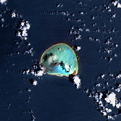
Deutsch: USGS-Landsat7-Satellitenbild des Kure-Atolls, Nordwestliche Hawaii-Inseln
English: Kure Atoll, Northwestern Hawaiian Islands - Satellite image from USGS' Landsat7 Satellite |
| Dato | Ukjent dato |
| Kilde | http://www.hawaiireef.noaa.gov/imagery/rpa.html |
| Opphavsperson | Landsat images were purchased by US Geological Survey |
Lisensiering
This image is in the public domain in the United States because it only contains materials that originally came from the United States Geological Survey, an agency of the United States Department of the Interior. For more information, see the official USGS copyright policy.
|
| This file is in the public domain in the United States because it was solely created by NASA. NASA copyright policy states that "NASA material is not protected by copyright unless noted". (See Template:PD-USGov, NASA copyright policy page or JPL Image Use Policy.) | ||
 |
Warnings:
|
Orginal opplastningslogg
Original Uploader was SeanMD80 (talk) at 12. mars 2006.
- 03:11, 12 March 2006 . . SeanMD80 (Talk | contribs) . . 1000×1000 (556,540 bytes) (Satellite image from NASA's Landsat 7 satellite {PD-USGov-NASA} http://www.hawaiireef.noaa.gov/imagery/rpa.html )
Filhistorikk
Klikk på et tidspunkt for å vise filen slik den var på det tidspunktet.
| Dato/klokkeslett | Miniatyrbilde | Dimensjoner | Bruker | Kommentar | |
|---|---|---|---|---|---|
| nåværende | 11. feb. 2009 kl. 00:09 | | 1 000 × 1 000 (427 KB) | Brisbane | color correction |
| 14. mai 2007 kl. 23:26 |  | 1 000 × 1 000 (543 KB) | Telim tor | == Information == {{Information |Description=25px Kure Atoll - Satellite image from USGS' Landsat7 Satellite 25px USGS-Landsat7-Satellitenbild des Kure-Atolls, Nordwestliche Hawaii-In | |
| 12. feb. 2007 kl. 23:29 |  | 600 × 600 (91 KB) | Telim tor | Satellitenaufnahme des Kure-Atolls |
Filbruk
Den følgende siden bruker denne filen:
Global filbruk
Følgende andre wikier bruker denne filen:
- Bruk i als.wikipedia.org
- Bruk i ca.wikipedia.org
- Bruk i de.wikipedia.org
- Bruk i en.wikipedia.org
- Bruk i eo.wikipedia.org
- Bruk i fi.wikipedia.org
- Bruk i frr.wikipedia.org
- Bruk i gl.wikipedia.org
- Bruk i hr.wikipedia.org
- Bruk i it.wikipedia.org
- Bruk i ja.wikipedia.org
- Bruk i lt.wikipedia.org
- Bruk i pt.wikipedia.org
- Bruk i ru.wikipedia.org
- Bruk i sh.wikipedia.org
- Bruk i uk.wikipedia.org
- Bruk i vi.wikipedia.org
- Bruk i www.wikidata.org
- Bruk i zh.wikipedia.org